Cumberland River
The Cumberland River below Lake Cumberland, is one of the premier trout fishing destinations in the southeastern United States. Home to the state record 21-pound brown trout, and a 14-pound, 6-ounce rainbow, the 75-mile long Kentucky portion of the Cumberland rivals any tailwater of the west. Wolf Creek Dam, which holds back the waters of Lake Cumberland, unleashes a powerful current that can be dangerous to any sort of water activity. At lower water flows, and when the dam is not generating electricity through its turbines, the Cumberland is ideal for drift boat fly fishing.
The first 16 miles of water from Lake Cumberland’s Wolf Creek Dam to Winfrey’s Ferry is a great place for canoeists, kayakers, and owners of small johnboats to float and fish the river. The ongoing repair work on Wolf Creek Dam, located south of Jamestown on U.S. 127, limits the amount of water the U.S. Army Corps of Engineers may release from Lake Cumberland during the summer months. The exception is when the lake elevation exceeds a certain level, and the Corps needs to drop the water rapidly. Trophy brown trout swim in the Cumberland River, as do bountiful numbers of rainbow trout. The river is also home to walleye, sauger and oversized striped bass.
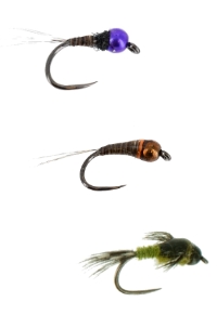
Popular flies include beadhead pheasant tail nymphs, princes, and hares ears. Also, smaller midge patterns work well for rainbows. The big browns found here eat the larger meat and potatoes style streamers.
For anglers who choose to float the river and fish hard without a lengthy shuttle, may launch at the Kendall Recreation Area ramp, located off U.S. 127 just below the dam. The takeout is at the old Kendall Ferry landing located at the end of Ray Mann Road. This makes for a float of approximately 1.75 miles with a shuttle of just a few minutes. This section includes the hatchery creek outflow, which is a great place to fish. Another place known as Boyd’s Bar, which is a productive wading shoal for rainbow and brown trout, lies at the end of Ray Mann Road. The next take out is a little over 4.5 miles downstream from Wolf Creek Dam at Helm’s Landing Boat Ramp, located off KY 379 via KY 55 and U.S. 127. Excellent rainbow trout fishing runs all through this stretch of the Cumberland River. It is a great section of river. Toward the end of this float, you will see two rock walls on each side of the river. Legend has it, that people removed these rocks and piled them near the riverbank to help steamboats power over a shoal in the river. This shoal, is probably one of the most productive rainbow trout fishing spots on the Cumberland River.
From Helm’s Landing, it is about a 6 mile float to the next take-out at the Rockhouse Natural Bridge, located off KY 379. In this section, the river is a series of shoals and long deep pools. Working the rocky edges of this section can be very productive. Near the end of this section, floaters will see the river take a hard left turn at a high bluff. This is whats know as the Rockhouse Hole. The Kentucky Department of Fish and Wildlife Resources recently purchased the island on the downstream left, just above the Rockhouse Hole. This island shoal is Long Bar, although some refer to the area as Snow Island. It is one of the better wading shoals on this section of the Cumberland River. Anglers may beach their boats on the island to fish this area.
The Rockhouse Natural Bridge take-out requires you to carry your boat through the arch and up a steep incline to the parking area. This take-out is not recommended for anglers in johnboats. The Rockhouse also serves as the put-in for the next section of river. Although the float from the Rockhouse to the next take-out at Winfrey’s Ferry is 5.5 miles on the water, the shuttle is just 1.5 miles. This is because the road connects the neck of a large bend in the river. A single paddler could drop off a boat in the Rockhouse parking area, drive down KY 379 to Winfrey’s Ferry, then walk back, leaving the vehicle parked at the end of the float. Rainbow Run, one of the best fishing shoals on the river, is just downstream from the Rockhouse. A long gravel bar on your right denotes Rainbow Run. The entire length of this shoal is worth many casts. Class I rapids downstream of this area provide lively paddling. A little further along on this float is Winfrey’s Rocks at downstream left. These rocks served as signposts for boat pilots back during the steamboat era. The rocks, located halfway through the float, mark a deep hole that holds bruiser brown trout. Striped bass also show up regularly from this section downstream. The rest of the float is a long, deep hole until Winfrey’s Ferry. Look for a cable that goes across the Cumberland River. This cable indicates the take-out downstream to the right.
The Cumberland River rises quickly when electrical generation begins from the dam. Powerful current created by more than one generator in operation makes the river unsuitable for paddlers. Log on to the U.S. Army Corps of Engineers Nashville District Web site at www.orn.usace.army.mil/ and click on the Recreation Info tab, then the Fishing Information tab followed by the Lake Cumberland tab. The daily fishing report contains the 24-hour generation schedule for Wolf Creek Dam. Boaters may also call (606) 678-8697 for current information. Floaters wanting to enjoy the Cumberland River may stay overnight at Lake Cumberland State Resort Park (1-800-325-1709) on U.S. 127, just a few miles north of Wolf Creek Dam. For those who prefer camping, the Kendall Recreation Area (270-343-4660) just below Wolf Creek Dam offers tent sites, hot showers, electrical hook-ups and drinking water.

Featured

Shop Tungsten Bead Competition/Perdigon Nymphs